
Building a safer backcountry

Image: Destination BC and Boomer Jerritt
New research shows consistent messaging, timely information, and better signage will reduce accidents
The turquoise waters of Century Sam Lake would make it a popular hiking destination on its own, but it’s the snow caves that attract the crowds. Meltwater feeding the lake carves channels through piles of winter avalanche debris. The snow caves at the mouth are a door into a world of blue light and cold breaths of wind. Looking into the snow cave is irresistible.
The 6.8 kilometres and 400 metres of elevation gain to get to the photo op seems reasonable to many. That was a solo hiker’s assessment earlier this summer when they set out to hike to the lake and back on July 12. Instead, later that day, search and rescue would be called out to find them, making the hiker a statistic.
By analyzing the roughly 2,000 search and rescue incidents that happen every year in B.C., researchers and advocacy groups are hoping to save lives. The new information is helping colour a more accurate picture for how to communicate backcountry safety and revealing the important role outdoor recreation clubs and land managers can play in keeping the public safe.
Earlier this year, the BC Coroners Service released its first-ever analysis of hiking and climbing fatalities in the province. Between 2016 and 2025, 143 people died, including 17 just in 2025. Of the total, 81 percent were classified as accidents, mostly from falls, and more than 70 percent of the fatalities were men, mostly in their twenties. The majority of deaths occurred during the summer months, peaking in July.
“It mirrors a lot of what we see in search and rescue data,” says Sandra Riches, executive director of BC AdventureSmart, the advocacy and education arm of the BC Search and Rescue Association. “It’s always good to look into the data. It helps steer us on the prevention side.”
AdventureSmart’s own analysis of search and rescue calls across the province has turned up a surprise that points to the important role local recreation clubs can play in prevention: 95 percent of people needing a rescue are from the local area.
“These are not visitors from another country. They are us,” Riches says. “Familiar territory often creates a false sense of security.”
Combatting that with education is Riches’ focus. First, by keeping the message simple. The Three Ts (trip planning, training and taking the essentials) have become the maxim. Next, by being consistent. Encouraging everyone from the media to outdoor clubs to repeat the same phrase in the same order. It helps the idea stick in people’s minds, Riches says.
“Consistency is king,” she says. “If Atlin is saying the same thing as Revy, that’s a win.”
Throughout the southern half of the province, AdventureSmart is targeting hikers, mountain bikers and off-road vehicle users, the groups most likely to need rescues during the summer, with the simple and consistent Three Ts message. Riches uses social media posts, media interviews and collaborations with partners including BC Parks. Riches says AdventureSmart is also looking to partner with other organizations, such as outdoor clubs.
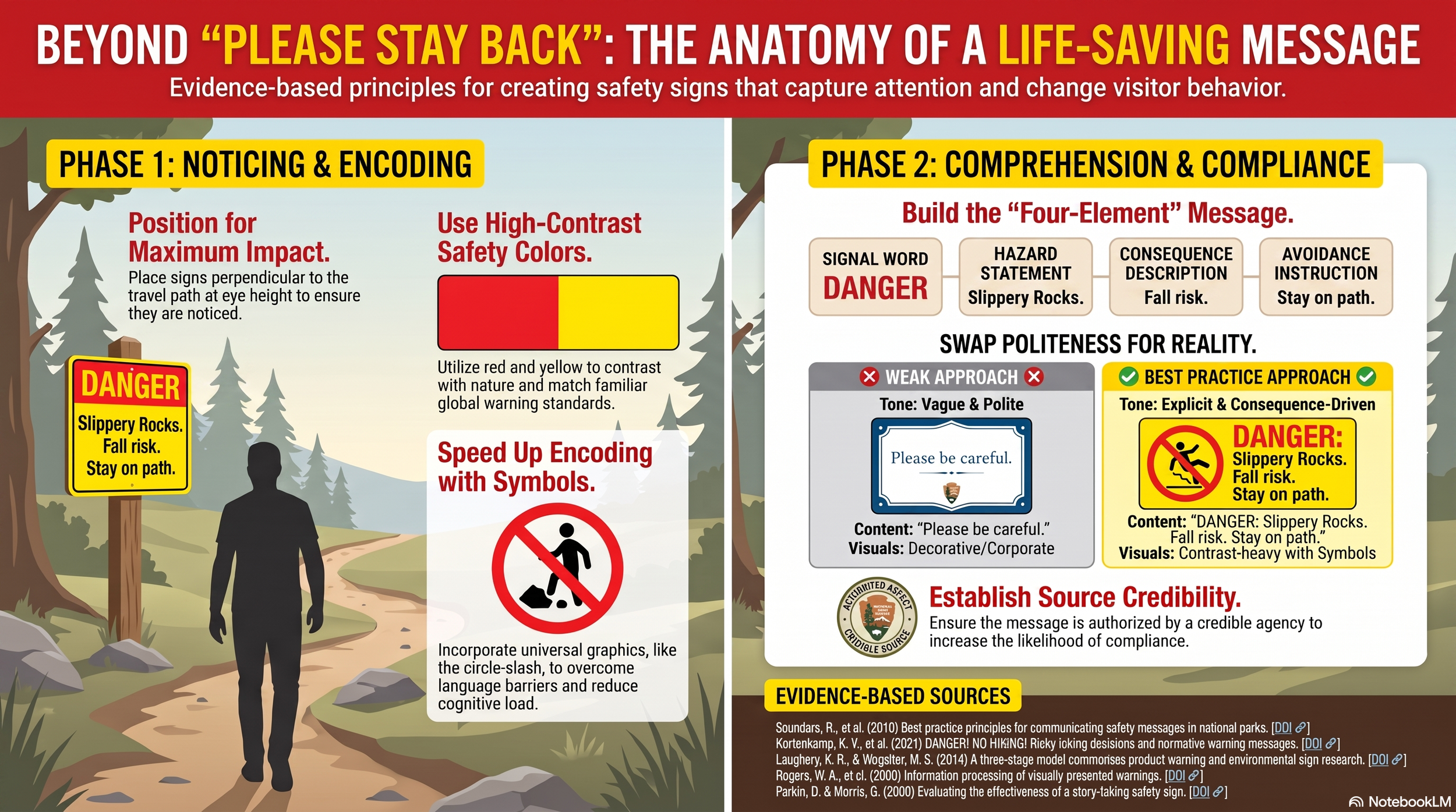
There is still a need for more targeted messaging to address specific hazards, users and locations. Physical signage is the tried-and-true method in many situations. And here, too, there is recent research that draws on new understandings of how people process information and risk. Our analysis of several studies listed at the end of this document shows that the messaging must work on multiple levels: noticing and encoding to quickly communicate the need to pay attention and then comprehending and complying to explain what to do to stay safe.
Noticing and encoding
Signs need to be eye-catching and easily understood. They should:
be placed perpendicular to the pathway of travel and at eye height
use colours that contrast with nature and match other familiar warnings (red and yellow)
include visual symbols, like a circle with a slash through it, to overcome language barriers and speed encoding
Comprehending and complying
Use short, negative descriptions that make hazards real and communicate the “why”. They should have:
a signal word
a statement of hazard
a description of consequence
a simple instruction on how to avoid it
For example, instead of “Please stay back,” better wording would be, “Many past visitors have been hurt here. Please stay on the trail to avoid the dangerous drop-off.”
There are other best practices to help keep users safe. A good place to start is coordinating messaging with various partners. When search and rescue, tourism organizations, outdoor stores, and other organizations all share the same information it makes it easier for people to comply. Using dynamic signs, that can be adjusted with the conditions, is also helpful. These are good for sharing changing conditions like up-to-date river levels, snow conditions and road access. And review it all, including signage, with trail users to see what’s working and what’s not.
Another good option is to register with AllTrails Public Lands Program. The digital platform is a back-end into the world’s most popular trail app and website. Approved land managers can adjust trail descriptions and send alerts about conditions.
Using the platform, employees at Olympic National Park in Washington state edited AllTrails descriptions of the park’s most popular trails and began sending out alerts on the app about weather and road closures. The effort reduced search and rescue incidents by 66 percent on its busiest trails. To find out more about the Public Lands Program read our BETA blog.
A more accurate description of the Century Sam trail might have saved the Comox Valley Ground Search and Rescue a call-out on that July weekend.
A better write-up could make it clear that the 6 kilometres was just one way on the out-and-back hike, that the rough logging road often stops cars well short of the trailhead, making the trek more like 15 kilometres, and that there are technical sections that challenge some.
Instead, when the hiker didn’t make it home on time, their emergency contact called 911. After a quick search, Comox Valley Ground Search and Rescue located them. They were unhurt and had just underestimated the time required for the route.
Better signage research links:
Best practice principles for communicating safety messages in national parks
The effectiveness of information signs in deterring visitor vandalism